The Town of Koingnaas

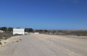
Koingnaas is a small village or town in Namakwa District Municipality in the Northern Cape province of South Africa. It is located about 65 km south of Kleinzee on the Atlantic Ocean. Once a flourishing diamond-mining town – created by the De Beers mining company in the 1970’s. Koingnaas falls under the Kamiesberg Munisipality who’s […]

How to get to Koingnaas

The small town of Koingnaas is situated on the Atlantic Ocean coast line in the Northern Cape province of South Africa, about 550km (370 miles) north from Cape Town. To drive from Cape Town to Koingnaas take the N7 national route that runs from Cape Town northwards through the West Coast and Namaqualand regions – […]

The History of Koingnaas – PART 1

The History of Koingnaas – PART 1 This is part 1 of 3: Koingnaas is part of the longest stretch of coastal desert on the planet. It is part of the Namibia Desert that stretch for nearly 2000 km from the Elephants River in the south to the Curunjamba River in the north of Angola. […]

The History of Koingnaas – PART 2

The History of Koingnaas  – PART 2 You can read Part 1 here: Jan van Riebeeck, the colonial administrator of the Cape of Good Hope (later Cape Town) sends, around 1662, a few men into Namaqualand – up north of The Cape, along the coast line to look for copper and other minerals of value […]

The History of Koingnaas – PART 3

The History of Koingnaas – PART 3 You can read part 2 here Diamonds In Namaqualand The first diamonds in Namaqualand  are discovered in 1925 in Port Nolloth, a small harbour town that was built to export copper-ore mined in Okiep and Springbok. Port Nolloth is about 150 km north of Koingnaas and between these […]

Nature Conservation In Koingnaas

Nature Conservation In Koingnaas Koingnaas is in the hart of the Namaqualand sandveld and only a short distance for the Richterveld – Conservation in the desert is essential. WATCH THIS SPACE: More on new conservation effort coming Soon….

Vintage Maps and Koingnaas

Below are a few Vintage Maps showing the position where the tiny town of Koingnaas would later be build. Studying the maps also give one and idea of how South Africa grow in 300+ years. Map number 5 is an map showing the different mining areas along the West Coast of Koingnaas. Most of these […]

Shipwrecks – Koingnaas Coastline

The west coast of South Africa – where Koingnaas is situated – is notoriously dangerous for ships – and its been dangerous for the last 500 years. 1000’s of shipwrecks lay around the coastline of South Africa – especially on the west coast. In this series of post we will tell share some of these […]